Why Town Streets Follow the Ground Beneath Them
Why town streets follow the ground beneath them: read slopes, creeks, and older routes to understand a street pattern without forcing one neat explanation.
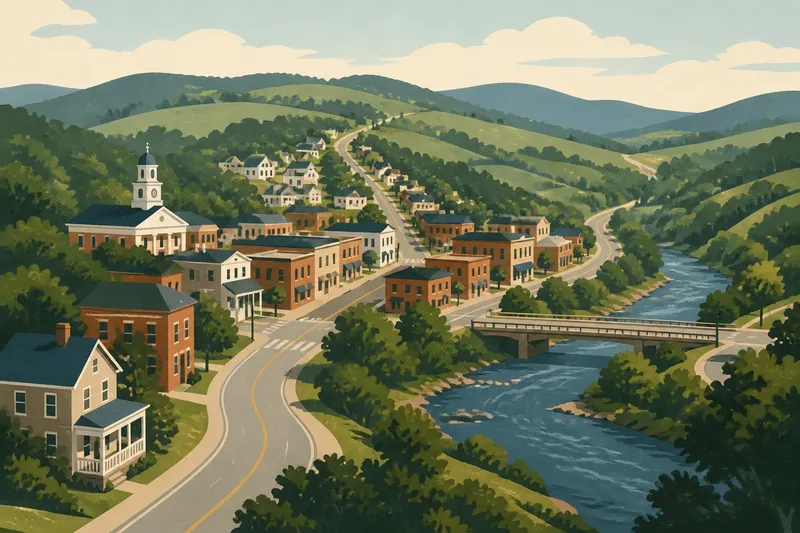
The common mistake in reading a Southern town map is to treat every bend as a planning decision. That can cost you the town’s older logic: a street may curve around a creek, climb a ridge, or preserve a route laid down before anyone thought to make the grid tidy. Why town streets follow the ground beneath them is not a single-answer puzzle. It is a way to notice where terrain, water, and inherited paths meet.
What does the slope ask a street to do?
Begin with the ground under your feet. A contour map, a topographic layer in a mapping app, or the rise visible along a block can show where a street is working with a hill rather than crossing it directly. In towns across the South, a road may bend along a ridge or climb by a gentler line where a straight route would make the ascent abrupt.
Look for what the street does at the crest. Does it run along the high ground, then drop toward a stream? Does it meet another road at a shallow saddle between hills? These transitions can explain why an apparently inconvenient turn sits where it does. The route may be connecting two usable grades, not aiming for a handsome angle on a map.
On foot, compare the slope of the street with the slope of nearby yards and driveways. A road that holds a steady grade while the land falls away on either side may follow a ridge or bench. One that climbs in short, uneven stretches may reflect changing terrain, later adjustments, or both. The street itself is evidence, but not a deed of explanation.
Do not assume that every straight street is a grid imposed without regard for the land. A long, straight segment can follow a broad ridge or a naturally level terrace. Conversely, a curve can be a later design choice, a boundary line, or a response to property ownership. The useful question is not “Was this street planned?” but “What conditions made this route practical here?”
Where does water leave its mark?
Creeks and rivers draw more than blue lines on a map. They can limit crossings, collect runoff, shape low ground, and make some routes easier to keep open than others. A street that follows a stream may stay above a flood-prone bottom, while a cross street may converge at a bridge, ford, or another narrow crossing point.
Notice the spaces around the water as well as the street names. A broad, irregular green strip, a drainage channel, a low park, or a line of back lots may preserve the shape of a former wet area. In a developed town, water may now pass through a culvert or a channel hidden behind buildings. The absence of an obvious creek does not mean the land forgot where it ran.
Compare a current street map with a topographic map and, where available, an older map in a local library or county archive. Look for a road that approaches a stream at a narrow point, then resumes on the opposite bank. That pattern suggests a crossing mattered, though it does not tell you whether the road, bridge, or settlement came first.
Imagine a visitor comparing two streets on opposite sides of a small creek. One bends toward a bridge, while a newer-looking block runs straight toward the channel and stops. The visitor might reasonably infer that the bend serves a crossing and that the straight street belongs to a different phase of development. The visible result is a useful clue, not proof of a town’s entire chronology.
How can an older route survive inside a newer layout?
Some roads predate the streets that now meet them. A route linking farms, a courthouse, a mill, a landing, or neighboring communities could become a town street as buildings gathered along it. Later blocks might be laid out more regularly, leaving the old route as a diagonal seam through the grid.
On a map, follow a diagonal beyond the town center. Does it continue toward a river crossing, a county boundary, or another settlement? Does it change name while keeping its line? Such continuity may point to an older connection. It may also reflect a property line or a survey choice, so look for supporting clues rather than promoting one angle into a complete history.
Street names can help, but they are slippery evidence. A road called Ferry, Mill, or Old Church may preserve a local memory, or the name may have been assigned long after the route changed. Check a county road map, a local historical map, or a planning document if you want to understand when the name appears. The map can reveal the line; records may clarify the label.
When an old route meets a later grid at an awkward angle, notice how the junction is handled. The result might be a triangular lot, a small wedge of sidewalk, or a building with an odd-shaped footprint. Those leftover spaces often show where one street system had to make room for another. They are not necessarily evidence of careless surveying; sometimes the town inherited a line it could not simply erase.
Which clues help separate causes?
A street pattern usually has more than one explanation. A creek can influence a route, while a ridge determines the route’s grade and a property boundary fixes its edge. To keep the reading grounded, compare several kinds of evidence instead of assigning every bend to one cause.
- Check the contours. If a street tracks a ridge or avoids a steep face, the terrain may be shaping its course. A contour map makes subtle rises easier to see.
- Trace the water. Look for creeks, drainage corridors, bridges, and low areas. A route that narrows toward a crossing may be responding to the available passage.
- Follow the line outward. A diagonal that continues beyond town may be part of a longer route. A line that ends at a boundary may have a more local explanation.
- Compare map editions. Older maps can show whether a street existed before surrounding blocks or whether a formerly open route was absorbed into later development.
- Notice the exceptions. A straight street through rough ground, or a bend on level land, calls for another possibility: ownership, a boundary, a later project, or a route that has since changed.
These clues do not produce a verdict by tally. One old map may be incomplete, and a present-day channel may differ from the stream shown on it. The aim is to make a modest claim that fits what can be seen: “This street appears to follow the ridge,” or “The bend may relate to the crossing.” Modest claims are less theatrical and usually more useful.
What should you look for on a town walk?
Choose a short route where the street pattern changes. A courthouse district beside a creek, a hilltop neighborhood meeting a flatter grid, or an old road entering a newer subdivision can all provide a compact reading exercise. Keep a paper map or phone map handy, but give the land more attention than the screen.
At each change, stop where it is safe and observe the direction of the slope, the nearest watercourse, and the shape of the junction. Look for retaining walls, steps, unusually deep lots, bridges, and gaps between blocks. These features do not explain themselves, but they help locate the places where the ground or an older route may have constrained later streets.
Do not confuse a view from a car with a reading of the street. A gentle rise can feel flat behind a windshield. Walking a block reveals whether the road climbs, levels, or falls away, and whether a side street meets it at the bottom of a slope or near a crest. On private land, stay on public sidewalks and paths; a good map does not confer permission to cross a yard.
Photographing a junction can help you compare it with a map later. Include a recognizable public feature, such as a bridge or street sign, rather than relying on a close view of pavement that could belong anywhere. A brief note about direction and slope is often more useful than a camera roll full of unexplained corners.
Why town streets follow the ground beneath them: what should you ask?
Does a curved street always follow a hill?
No. A curve may track a contour, avoid a wet area, follow a property boundary, or reflect a later design. Check the surrounding ground and older maps before treating the shape as evidence of one cause.
Can a grid exist on uneven land?
Yes. A grid may continue across varied terrain, with streets changing grade or ending where slopes and waterways make continuation difficult. Regular blocks can therefore sit alongside older, less regular routes.
How can I tell whether a road is older than the blocks around it?
Compare maps from different periods and see whether the route appears before the surrounding streets. A diagonal that continues beyond town or links established destinations may support that reading, but maps can omit minor roads.
What if the maps disagree with what I see?
Allow for changed channels, removed crossings, and streets that were rerouted or renamed. Use the mismatch as a reason to check another map or local record, not as a reason to force the evidence into a neat story.
When is it sensible to stop interpreting?
Stop when the clues no longer support a clear distinction among terrain, ownership, and later construction. A street can preserve several decisions made at different times, and a present-day observer may not be able to separate them from maps alone. Local planning records, county archives, or a librarian familiar with regional maps can provide a next source if the question matters beyond a walk.
The practical payoff is a better way to read an ordinary intersection. Ask what rises, where water gathers, and whether the route continues past the town’s edge. Why town streets follow the ground beneath them becomes easier to see when the map is treated as a set of clues rather than a diagram with one hidden answer. Carry that habit to the next bend, and let the landscape keep some of its uncertainty.